Há muitos séculos, as verdes pastagens da Serra do Açor, atraíam grupos de pastores que aí levavam os seus rebanhos. Diz‐se mesmo que esses pastores seriam os Lusitanos, hábeis criadores de cavalos que povoavam os Montes Hermínios (Serra da Estrela). Ao longo dos tempos as populações foram criando condições para a sua subsistência, conquistando à Serra cada pequena leira cultivada em socalcos. A agricultura, pastorícia e a apicultura constituíram assim as principais atividades das populações. Pelo alto da Serra do Açor passava a antiga estrada real que ligava Coimbra à Covilhã por onde circulavam caravanas de carros de bois que traziam do litoral o peixe e o sal para levarem no regresso a carne, o queijo, os lanifícios e até gelo, das terras do interior.
Para além de histórica, a Serra do Açor é um concentrado de beleza natural, é uma montanha fendida por dezenas de ribeiras de águas límpidas e pequenas e belas povoações que merecem ser descobertas, como é exemplo as Aldeias do Xisto de Benfeita e Vila Cova de Alva. Nesta área é possível ainda encontrar uma das relíquias da floresta autóctone portuguesa, a Mata da Margaraça, que integra a Paisagem Protegida da Serra do Açor e a Rede Natura 2000.
Como chegar:
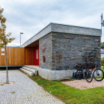
Para chegar a Coja, onde se localiza a estrutura de acolhimento de Centro Cyclin’ Portugal da Serra do Açor, a partir da A1, deverá utilizar-se a saída de Coimbra Norte, seguindo o IP3 em direção a Viseu durante aproximadamente 28km, saindo no IC6 em direção a Arganil. A partir do IC6 poderá dirigir-se para Coja via Arganil pela EN342-2 e EN342 ou sair diretamente da IC6 para a antiga EN344 até Coja. Já em Coja deve dirigir-se ao parque do Prado.
– Percurso Preto – Centro Cyclin’ Portugal da Serra do Açor
– Percurso Vermelho – Centro Cyclin’ Portugal da Serra do Açor
– Percurso Verde – Centro Cyclin’ Portugal da Serra do Açor
– Percurso Azul – Centro Cyclin’ Portugal da Serra do Açor
Folheto Centro Cyclin’ Portugal da Serra do Açor
Painel – Centro Cyclin’ Portugal da Serra do Açor
Financiamento:
Programa Operacional Regional do Centro – Mais Centro
ENG: Set up in the village of Coja, Municipality of Arganil, the Serra do Açor Cyclin‘ Portugal Center is integrated in the territory which gives it its name. Açor Mountain is a predominantly schist mountain that integrates the central mountain range, together with both Lousã and Estrela Mountains. It covers most of the municipalities of Arganil and Pampilhosa da Serra and part of the municipalities of Góis, Oliveira do Hospital, Seia and Covilhã, reaching its highest points at S. Pedro do Açor (1342m) and Cebola (1418m), extending over an area of more than 25,000 hectares (250 square kilometres).
For many centuries, the green pastures of Açor Mountain attracted groups of shepherds that took there their herds to graze. It is even said that these shepherds would be the Lusitanians (Lusitani), skilful horse breeders who populated the “Montes Hermínios” (Estrela Mountain). Throughout the ages, the local populations created the conditions for their subsistence,
“fighting” with the Mountain to “conquer” each small “leira” (agricultural land) cultivated in terraces. Agriculture, sheep farming and beekeeping were the main activities of the populations. The old royal road passed on the top of Açor Mountain connecting Coimbra to Covilhã. Caravans of ox carts circulated here, bringing fish and salt from the coast and in return taking meat, cheese, wool and even ice from the hinterlands.
In addition to its historical character, Açor Mountain is a concentrate of natural beauty, a mountain split by dozens of clear water rivers and small and beautiful villages that deserve to be discovered, such as the Schist Villages of Benfeita and Vila Cova de Alva. In this area, it is also possible to find one of the relics of the Portuguese endemic forest, the Margaraça Woods, which
integrates the Açor Mountain Protected Landscape and the Natura 2000 Network.


